JUMP TO COURSE
10K COURSE
10K Course Colors:
ORANGE Loop
Course Difficulty:
Cut-off Time:
4-hours
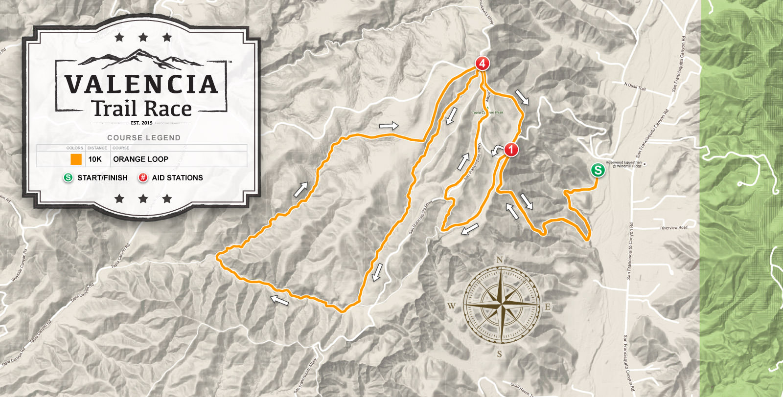
10K runners will complete the ORANGE 10K loop. From the start, all runners will climb a 500-foot elevation gain to get up into the mountain trails reaching station #1 and begin the course loop. 10K runners simply follow the 10K course around from stations #1, to #4, then again to #4, and returning back to station #1, finally heading back to the finish line.

Mobile phone users, please rotate to landscape mode to properly view tabel below.
10K runners will visit a total of 4 aid stations through the course. Below shows the sequence and approximate mile mark for each station on the 10K course.
| STATION | MILE* | NOTES | |
|---|---|---|---|
| 1. | Start | 0 | Start ORANGE course |
| 2. | Station #1 | 1.1 | Hairpin turn at the top |
| 3. | Station #4 | 1.8 | After reaching Tapia Canyon peak first time, follow the Stars & Stripes trail to left (the station is just past the trail entrance). *NOTE: It is approximately 3.2 miles gap until you return to this station, recommend hydrating and refueling before departing. |
| 4. | Station #4 | 5 | Tapia Canyon peak, by power tower, go right then left the trail to #1 |
| 5. | Station #1 | 5.4 | Zigzag turn, head back to the big hill going down |
| 6. | Finish | 6.5 | Finish Line |
*Approximate mile mark distances.
Stations will contain water, Gnarly Sports Nutrition Hydrate or Fuel2O electrolytes, GU gels and chomps, salt capsules, energy bars, crackers, licorice, and various foods. Items will vary from station to station, other essential items include a first aid kit, ice packs, and toilet paper. We highly recommend that you plan to run with a runner's bottle or hydration pack, you can refill them at each station with water and electrolytes.
The GPS files below can be saved to your computer or phone and uploaded to your app or GPS tracking device. These are XML format files, once you click the button below, save the file then load it into your chosen destination.
HALF MARATHON COURSE
Half Marathon Course Colors:
ORANGE + BLUE Loops
Course Difficulty:
Cut-off Time:
6-hours
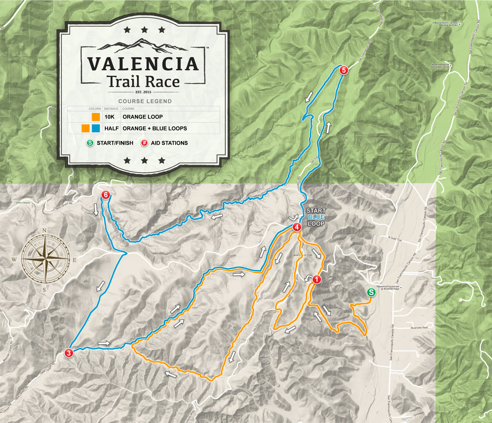
Each course is a loop with longer distances breaking off at specific points to extend the distance from the previous loop. All runners will complete the ORANGE 10K loop, Half Marathon will also complete the BLUE loop. From the start, all runners will climb a 500-foot elevation gain to get up into the mountain trails reaching station #1 and begin the course loops.
Half Marathon runners will follow the 10K loop to station #4, then go LEFT to begin following the BLUE loop to station #5, then station #6, then station #3, then returning getting back on the section of the ORANGE loop to complete the BLUE loop coming back to station #4 (third time here), from this point now continue the remainder of the ORANGE loop going back to station #1 and the finish line.

Mobile phone users, please rotate to landscape mode to properly view tabel below.
Half Marathon runners will visit a total of 8 aid stations through the course. Below shows the sequence and approximate mile mark for each station on the Half Marathon course.
| STATION | MILE* | NOTES | |
|---|---|---|---|
| 1. | Start | 0 | Start ORANGE course |
| 2. | Station #1 | 1.1 | Hairpin turn at the top |
| 3. | Station #4 | 1.8 | After reaching Tapia Canyon peak first time, follow the Stars & Stripes trail to left (the station is just past the trail entrance). *NOTE: It is approximately 3.2 miles gap until you return to this station, recommend hydrating and refueling before departing. |
| 4. | Station #4 | 5 | Tapia Canyon peak, go under power tower to start BLUE course |
| 5. | Station #5 | 6 | Fireroad fork, go left horseshoe turn to trail |
| 6. | Station #6 | 8.5 | After a long canyon section |
| 7. | Station #3 | 9.8 | After the fire road section, return to the canyon |
| 8. | Station #4 | 11.6 | Tapia Canyon peak, by power tower, continue on ORANGE course go right, then left trail to #1 |
| 9. | Station #1 | 12 | Zig zag turn, head back to the big hill |
| 10. | Finish | 13.1 | Finish Line |
*Approximate mile mark distances.
Stations will contain water, Gnarly Sports Nutrition Hydrate or Fuel2O electrolytes, GU gels and chomps, salt capsules, energy bars, crackers, licorice, and various foods. Items will vary from station to station, other essential items include a first aid kit, ice packs, and toilet paper. We highly recommend that you plan to run with a runner's bottle or hydration pack, you can refill them at each station with water and electrolytes.
The GPS files below can be saved to your computer or phone and uploaded to your app or GPS tracking device. These are XML format files, once you click the button below, save the file then load it into your chosen destination.
50K COURSE
50K Ultra Course Colors:
ORANGE + BLUE + PURPLE Loops
Course Difficulty:
Cut-off Time:
9-hours
2023 50K COURSE UPDATES
Two major changes are made to the 50K section starting with the 2023 race.
- First: We removed the out and back section after station #8 to the u-turn which was on the paved road. There was too much public traffic making for unsafe conditions on the narrow road. To make up the distance from the removed out/back it has been moved to the out and back by station #7. This means you will only hit station #8 once and no more paved road, it's all dirt. Station #8 will still be your gear drop spot.
- Second: Due to the heavy winter rains this year a section of the road that leads up to the 3-way intersection where station #7 usually is located, is currently not unpassable with a 4x4 or AWD vehicle. Instead, station #7 will move down to the u-turn location by the gate/road entrance. This means you will hit station #7 twice, first after passing #5 heading towards #8, then when returning from #8 you will go back to station #7 again before continuing to #5 and the finish.
These changes mean 50K course will now be 30.6 miles and runners will hit a total of 14 stations during the race.
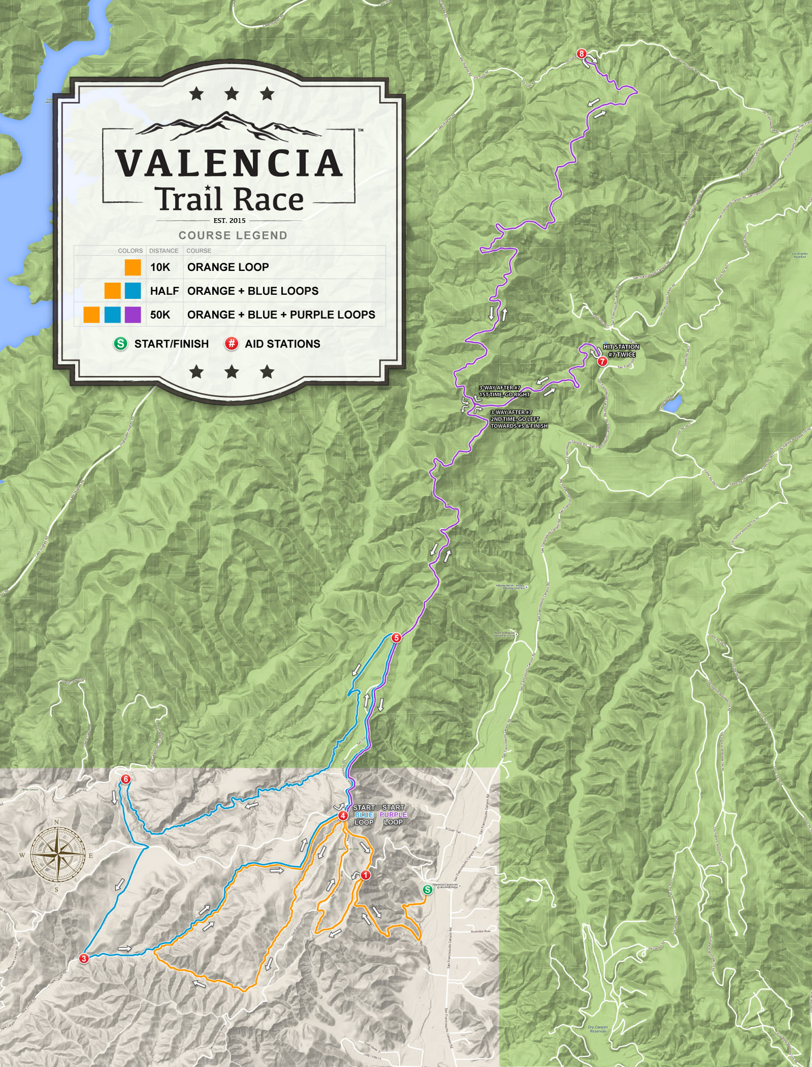
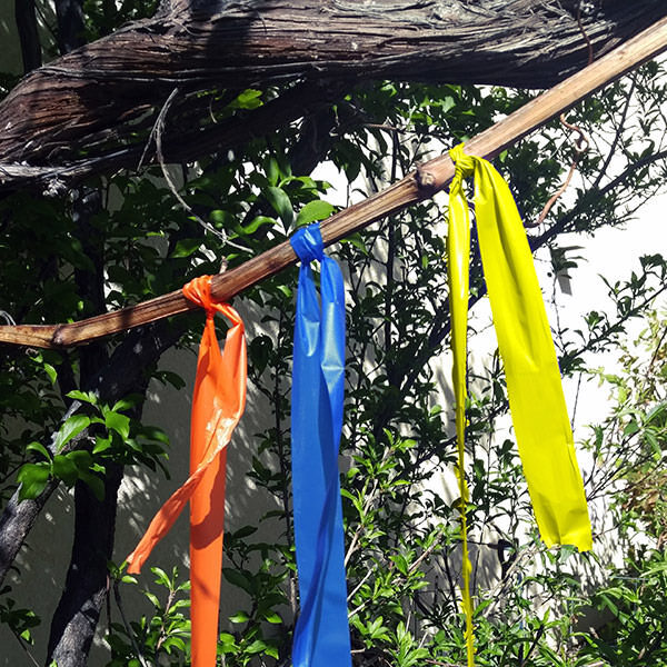
Each course is a loop with longer distances breaking off at specific points to extend the distance from the previous loop. All 50K runners will complete the ORANGE 10K loop, the BLUE Half Marathon loop, and the PURPLE (YELLOW flagging) 50K course. From the start, all runners will climb a 500-foot elevation gain to get up into the mountain trails reaching station #1 and begin the course loops.
50K and Half Marathon runners will follow the 10K loop to station #4, then go LEFT to begin following the BLUE loop to station #5, then station #6, then station #3, then returning getting back onto a section of the ORANGE loop to complete the BLUE loop coming back to station #4 (second time here).
Now 50K runners take the LEFT fork to begin the PURPLE LOOP (YELLOW flagging) going to station #5 and take the RIGHT going towards the large 3-way intersection, go RIGHT to station #7 and complete a U-TURN back to the 3-way intersection, now go right towards station #8 to complete a U-TURN to the 3-way intersection, then #7 (second time), after coming back up to the 3-way intersection go left going towards station #5 (third time here) and #4 (third time here) to complete the PURPLE course, from this point now continue the remainder of the ORANGE loop going back to station #1 and the finish line.
Note: 50K ultra course is approximately 50/50 trail and fire access road.

* Readings on elevation gain/descent varies from all platforms and devices. This is the best reading we currently have with 7261 ft for the 50K.
Mobile phone users, please rotate to landscape mode to properly view tabel below.
50K ultra runners will visit a total of 14 aid stations through the course. Below shows the sequence and approximate mile mark for each station on the 50K ultra course.
| STATION | MILE* | NOTES | |
|---|---|---|---|
| 1. | Start | 0 | Start ORANGE course |
| 2. | Station #1 | 1.1 | Hairpin turn at the top, follow the trail to left |
| 3. | Station #4 | 1.8 | After reaching Tapia Canyon peak first time, follow the Stars & Stripes trail to left (the station is just past the trail entrance). *NOTE: It is approximately 3.2 miles gap until you return to this station, recommend hydrating and refueling before departing. |
| 4. | Station #4 | 5 | Tapia Canyon peak, go under power tower to start BLUE course |
| 5. | Station #5 | 6 | Fireroad fork, go left horseshoe turn to trail towards the rainbow bench |
| 6. | Station #6 | 8.5 | Coming out of the long canyon section, go left climb up |
| 7. | Station #3 | 9.8 | After the fire road section, return to the canyon |
| 8. | Station #4 | 11.6 | Tapia Canyon peak, by power tower, start the PURPLE course (YELLOW flagging) going left under power towers |
| 9. | Station #5 | 12.6 | Fireroad fork, go right |
| 10. | Station #7 | 15.7 | 3-way fork, go right to u-turn to reach station #7 |
| 11. | Station #8 | 20.3 | Dry Gulch Road, u-turn to head back to #7. Gear drop station. |
| 12. | Station #7 | 25 | 3-way fork, go left to #7 u-turn again. |
| 13. | Station #5 | 28.2 | Fireroad fork, go left back to #4 |
| 14. | Station #4 | 29.2 | Tapia Canyon peak, go left to #1 |
| 15. | Station #1 | 29.6 | Zig zag turn, head back to the big hill |
| 16. | Finish | 30.6 | Finish Line |
*Approximate mile mark distances.
Stations will contain water, Gnarly Sports Nutrition Hydrate or Fuel2O electrolytes, GU gels and chomps, salt capsules, energy bars, crackers, licorice, and various foods. Items will vary from station to station, other essential items include a first aid kit, ice packs, and toilet paper. We highly recommend that you plan to run with a runner's bottle or hydration pack, you can refill them at each station with water and electrolytes.
The GPS files below can be saved to your computer or phone and uploaded to your app or GPS tracking device. These are XML format files, once you click the button below, save the file then load it into your chosen destination.
SPONSORS & PARTNERS
Welcome race sponsors & partners. We are currently accepting sponsor applications for the race, learn more.
Thank you to our 2025 sponsors for thier incredible support in making our race experience awesome!
